Banasura Trekking – The toughest one I have ever done
 The giant of Banasura has been in my “to do” list for a long time now. Each and every time I plan for this some or the other impediments come in and it gets adjourned. I have been planning this ever since I have done Chembra trekking long back. This time it happened all of a sudden reminding me about the golden rule of travelling again. DO NOT plan your travel in advance. Let it happen all of a sudden. A good traveler never plans his routes. I read about a new place recently in a magazine and was so thrilled on the descriptions and pictures provided in the magazine. I called them up and inquired about the possibility of booking the dates for the coming Sunday. As it was near Kottayam I could easily manage the travel to and fro and endeavor the trekking as a one day affair. But to my disappointment the organizers were having some other preoccupations and there was nothing more they could do but to deny my query. I badly needed a day out there and hence couldn’t stop my urge myself to find another one. It was Wednesday night and the very next day called up Sijo Chettan (“chettan” is Malayalam for Brother) guide of Banasura for checking the availability. He was also preoccupied but promised to arrange another person and he passed me the number of George another guide.
Now the second thing how to reach Wayanad. Went to check the availability of tickets. Luckily there was. But before booking the tickets I thought of taking someone along. There were a list of people who promised to join me for next trek irrespective of the place and date. But knowing the fact that Banasura was rated among the tough ones in Kerala I was filtering the list to a larger extend as I didn’t wanted to invite someone just to give them trouble and the climate also was worth enough to worry about. The summer was just getting bad to worst. it was burning hot all over Kerala and Wayanad was having the most notorious rate of degrowth in summer precipitation (almost 99 % less compared to last year). In such a short notice there were little choices left but I tried Ajith. He was with me for Brahmagiri Trekking and Meesapulimala expedition. As I knew he would manage I decided to call him or to do it alone. He was just one ring away from the trek and we two planned as usual to leave Cochin by Saturday night. To do trekking on Sunday and return by Monday morning. I booked the ticket for both of us.
I was little busy with office schedules for two days and an unexpected Harthal came in between and Saturday Kerala celebrated the Harthal in its own way. But our plans went unshattered. Ajith somehow coped to get a train by Morning 10 and reached Cochin by 3 pm. I picked him up and he waited at my office till the time I could get out. Being a Harthal day it was manageable to get out by 6 pm and we went to room for a quick freshen up. By 7.45 we were at the Bus stand and boarded the bus after a quick purchase. We tried getting some sleep and succeeded. The bus reached Kalpetta at 2.30 pm little earlier than we expected and we checked into a hotel before it was 3 am. Though we had a fair enough time to take a nap we couldn’t. By 6 pm we had to take a bus from Kalpetta to Padinjarethara from where we need to get the food for the day and take an auto to reach Kappikulam Meenmutti falls entry gate. One can reach Padinjarethara via bus from Pinangode junction near to Market. It is 18 km from Pinangode junction 19 Rs point in KSRTC bus. The first bus comes at Pinangode junction at 6 am. Those who want to go are advised to take food from Padinjarethara as after that point you seldom get anything.

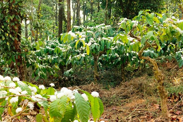 The morning mist was too surprising for a hot summer and it was blooming time of coffee plants. Throughout the entire stretch from Padinjarethara to Kappikulam coffee plants where seen bloomed and the graceful fragrance was so refreshing early in the morning. By 6.45 we reached Padinjarethara junction but none of the hotels were functional by that time as the Morning was followed by a Harthal day. By 7.45 we had our breakfast and collected food for the day. By 8.10 we reached Kappikulam taking an auto from Padinjarethara. Kappikulam is hardly 5 km from Padinjarethara and we can get there by auto from Padinjarethara. They will charge you 80 – 100 bugs. Those who want to visit Banasura Dam should get down before the ticket counter. The auto driver may help you getting down at the correct place. Reaching Padinjarethara itself we have informed our guide George about our arrival and he was there in the ticket counter by 8.10 am. Completing the formalities there we started our trek by 8.20 am.
 There are different types of trekking option available at Banasura. 3 hrs trekking for 10 members is Rs 750 – severity easier, Half day trekking for 10 members is Rs 1200/- Severity Moderate and full trekking for 5 members is Rs 1500/- severity moderate to tough. Guide charges will be additional for all this treks and will be applicable as per their discretion. Better ask for exact details before committing the trekking.
We kept the “not so necessary things” in the counter itself for ease and started our trek by 8.20 am. The initial path was a tarred road for 200 mtrs and after that we diverted into a mud road which very soon transmuted into a steep climb. Within some 10 minutes or so we were moving through a forest path which was steep enough to create trouble for us. The sun has started its effect in the early hours of the day itself. As we moved forward the path came narrow and we were moving more into dense forest covers. After some time we diverted again from the motorable path and entered into a foot path which was completely covered with fallen leaves and with thick covers all around. I cautioned myself and Ajith for leeches but luckily there was none. Though we were inside think forest it was hot and the layer of floor leaves were dry enough not to feed leeches.


 The path was little straight for half a km and then it turned steep again. We reached a dried out stream in half an hour .It was easy to cross. Our guide remembered the good old days of this stream when it was not possible to cross the stream walking even in the hottest summers. The gradient continued to be the same after the stream also and George said this used to be a road earlier to bring in woods from the interior of forest. After 10-15 minutes the road disappeared and we were walking though rocky patches and forest for almost half an hour. Found it very difficult as the dry leaves were slipping and it was hard to step over the uneven rocks. It was a tiring exercise to climb over rocks with the bag and camera and we almost covered 3 kms by now. Both of us were gasping for breath and it was very hot. Our guide said from now onwards we have some plain grounds to cover for almost 2.5 km it was an ear soother as our lungs and limbs were already having a tough time to cop up with the gradient. But at the mean time George warned us that after this plain terrain it will be hard core climbing for the rest of the distance. Those words hit us like a bullet train.


 Banasura trekking can be mainly divided into five parts. 1. Initial steep walk through the muddy terrain and forest -1.5 km, 2. Rocky and forest path – 1.5 km, 3. Plain grass land – 2.5 km, 4. Very Steep grass lands and rocky terrain for 3 km, 5. The most difficult thick forest covers 1.25 km. We can experience all terrains in one go. Banasura trekking is a super mixture of all terrains including, Muddy paths, Forest, Rocky paths, Steep climbing, Shola forests, Grasslands, and Thick dense untapped forest covers.


 The plain ground was mostly grasslands and was comparatively easier to cover. We were having some good views. During this stretch we can see the Kattukunnu and Sayippu kunnu very clearly. It is said that on top of Kattukunnu we can always feel a moderate wind and hence the name. Half day trekking is available over Kattukunnu. Sayippu kunnu is taller than Kattukunnu and is distinctive in its terrain. Sayippu kunnu is a giant peak which is equally decided into two parts one is a completely rocky and the other part is thick forest. Long view of Sayippu kunnu is really good. This peak got this name after a foreigner who believed to have lived on the other part of the peak. There is a rocky structure over the mountain which resembles the family of this foreigner his wife son and their dog. Full day trekking is available over Sayippu kunnu for the same rate. The trek is actually very steep at some places more than Banasura but the height is nowhere comparable.


 We had the first clear view of the top of Banasura peak also during this stretch. It was very hot in the grass lands and the Sun god was juicing our entire courage and at some points I even doubted whether we could complete the stretch. Top of Banasura was seen still far away like a job which we feel have to be left undone. Before we end the plain ground we entered a shola cover and there we saw a small stream and dried out water falls which could be mighty in rainy seasons. The water was chilling cold and we had no second thought than to get wet. As there was not enough water to dip in we took water from the stream and poured over the head. It was really refreshing and some energy rolled into the muscles to continue the stretch. To reduce the steep climb we detoured to the mountains lower end and started the climb. From the plain grounds we can start the climbing either through the forest or through the grass lands. If we move through the forest it is very steep but we can save half an hour but have to spend the whole of our energy. As we were planning to go as far as we can I opted the less steep grass lands though we have to walk half an hour more


 What our guide said was absolutely right. From the plane ground the real challenge of the day started. From this point we have to climb almost five small small peaks to reach the top of Banasura. The very first peak was very steep and so discouraging. But we were not ready to give up so easily. There was no cleared trails in this stretch we just had to climb up through the grass lands watching each steps as there were loose rocks all the way. Two three times I slipped and twisted the angle but was lucky enough not to land in trouble.

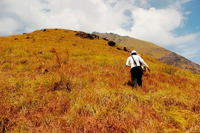
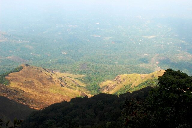
 As it was summer the grass lands have started to lose the beauty of the green carpet effect. The view of Banasura Dam reservoir was getting clear as we attained more height. Water level was down and we could see all the 28 islands in the reservoir. The long view of the Dam was so beautiful. Sayippu kunnu and Kattukunnu was becoming dwarfs as we climbed up. The View behind was also really good. The ridge we crossed gave us some pride and energy to continue. By 12.30 we reached the third level from the top. We had a brief there without which we felt it impossible to continue. The view from this point was impossible we could see the entire stretch of mountains. After the rolling mountains we could see the reservoir of the dam and the cotton clods doing magic in the sky. The combination of the green mountains Blue reservoir and the sky was superb. Cameras cannot capture all details. We could see the dense forest as far as eye sights allows. The rolling mountains with shola forest margins were the most beautiful things to look at from this point. We would come to know the real height we are at by comparing the size of Building in the plain grounds which looked like just dots.


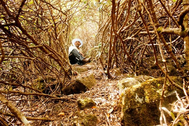
 The top of the grassland was visible from here. Now we had another steep cruel climb to complete to reach the top of the grass lands. We spend some 15 minutes there and left our complete baggage there. Just took the camera, 1 bottle of water and food was carried by George. It was literally a cruel climb from this point. All the energy was drained out by this time and the very sight of the inclination of the peak was so discouraging. I adopted the old idea of not looking over to the top. Thought of taking the photos when we descend. I looked down and counted the step one by one. Ajith had to stop every 50 mtrs to catch breath. I did my best not to look at the top. In another 30 minutes we reached the top of the grass lands. All I could do was to crash down on the ground. My legs were shivering. It took some minutes for me to come to the normal stage. We had food there which was comforting. From this stage it is only 1.25 km to the top of the peak but it was through very thick forest. The kind of forest I saw there I should admit I have not been into such thick forest nowhere in the near past. We literally had to crawl full length at some places for meters. The obstacles we covered were so bushy that our face, hands, legs and all the body was getting bruises. I had a burning effect when sweat wetted into the bruises. I was encountering such a horrible trek for the first time in my whole travel experience.


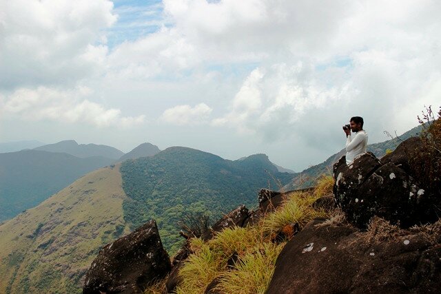


 The trill of the wilderness over crossed the fatigue and finally after 45 minuted we reached the top most point of the peak. The views were not that good as there was no vantage point on the top. The place was so wild and I felt like leaving the place as soon as possible It was covered by thick forest. The rock I found there was no way accessible. I tried getting on top of that but failed. Realizing the fact that it would be fatal to attempt again I gave up the idea. Still it was something well done and I consider this as my toughest trekking ever. Any mishaps at this stage would cost you more than you could imagine. We were at 6800 feet high 9 km away from a motorable road, and 1.25 km inside a dense, untapped, pristine and dangerous forest.

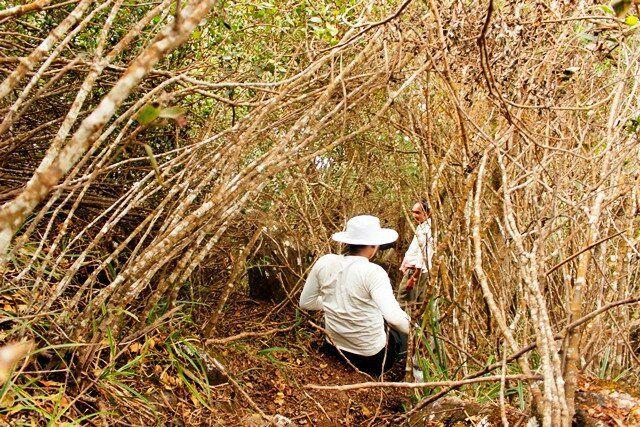


 We were already a bit lagging behind the time lines and George wanted to get down as fast as possible. Both of us were feeling dead tired but had to rise to the situation. It was becoming a little cloudy and if it rains it will be very difficult for us to get down before it gets dark. It was not even imaginable to walk through the forest in the dark through this terrain. Without wasting much time we said good bye to Banasura top station and started to get down. Felt so happy to be there where not much people have been. George remembered that it was 4 years back in 2011 some one last came and reached the top. It was a moment of proud to step over the top. The forest stretch was the most difficult to cross.
Getting down was also equally time consuming because the dried grass were so slippery that we had to take care at each step not to land on the butt. After getting down the steep hills we cleared the plain stretch at one go as we had some time to cover up. We had a quick stop at the stream again for cooling down the engines. Legs were throbbing and shivering like anything. We took 5 mins breaks after every 30 minutes. We really struggled over the last and final stretch down the line. We reached the ticket counter back at 6.15 pm totally drained out. Dropped down on the first seen bench to catch hold of our breath. By 6.45 we left Kappikulam saying goodbye to all. Our guide George helped to get an auto and we reached Padinjarethara and from there to Kalpetta. By 8.30 we got a Kozhikode bus from Kalpetta and from Kozhikode we got a Bus to Trivandrum. By 4.30 am I reached Cochin and Ajith carried on in the same bus to Trivandrum.
Though it was a strenuous day both of us thoroughly enjoyed the trekking. I should say it was the most tough and effective trekking I have done so far. Thanked Mother Nature for keeping us safe for the entire day before going to sleep. Went to sleep with a heavy pair of legs but with a light weighed heart and stress relieved mind.
****************************************
You can reach
Please note : Some Important points are Underlined and colored for easy finding and the links to my other posts are also colored and underlined


bhai,….kollam…ente nadinu etrayum bangi undairunu le….
Yes Prajith. Your place is so beautiful. There are many more to explore there. Waiting for the next visit to Wayanad. Please let me know if you know some places potential for trekking.
Thanks for visiting the site do visit again. We will keep in touch
Awesome man!!
You set a new benchmark for all of us. I’ll try to break that.
The narration was so detailing that I felt my legs on top of banasura.
Thanks buddy…break the benchmark… But dare not to challenge nature… I am ur competition not her.. :):):)
banasura was one of my best places as well gr8 write-up again
Thanks Sandeep… To be honest i got inspired from your blogs only… The moment I read your blog of Banasura long back i have decided to do that… But it took some time to materialize… besides I was lucky enough to cover the last forest stretch
Pingback: Nature Calling | Vellarimala trek
Hello Brother,
Your blog is detailed and informative. Thank you so much. I have deceide to go to Banasura this July. Will it be good in this month ? And could you help me out on how to arrange for the trek personally as i am just a college student and a beginner ? If you are okay with it please whatsapp me to 9884496222..!!
Dear Ashwin..
Good to know that the content was informative. though now it is open June July August Is Monsoon in Kerala. You wont be able to do it in this months. Mostly the package trekking will be closed by this time due to rough weather and Wild life issues. Post Monsoon is the best season ( September to January). Banasura trek would be a tougher one for a beginner. But if you have a strong will in mind to do it nothing is impossible.
Hello! thank you for the details of this trek.
Do you have a number that I can call the permit office to check if the route is open for trekking ?
Please note that I do not speak any malayalam and hence it would be hard for me to communicate.
Would appreciate your help!
Thank you
Hi Sahil
Just spoke to the concerned person. Its raining there and hence trekking packages are stopped for the time being. Expecting to resume after first week of Aug if rain is getting subsided. Please plan accordingly after that. If you want me to check the climate after first week please drop me a msg/mail my number is 9745112411 and mail id
Thanks for visiting the site
Dear Rakesh,
I along with a couple of friends was planning to go for a trip in Wayanad. While searching for the details just happened to see your travell guidelines.
I truly admire your detailed explaination. And I with all the respect for your efforts I thankyou for your wonderful guidelines.
I feel like I spoke to a close friend who came just after the complete trek.
Thanks buddy. Hats off to you.
Thanks Joseph.